GPS Features of BKR Series Radios

All modern BKR series radios come standard with GPS features. The radio can connect to GPS satellites to determine its position. There are many different methods to then transmit this data to other radios.
Manual-
Once the radio has acquired its position, users can access the GPS menu and display their location on the face of the radio. From this screen, users can read their location and activate PTT to send this data over the air.
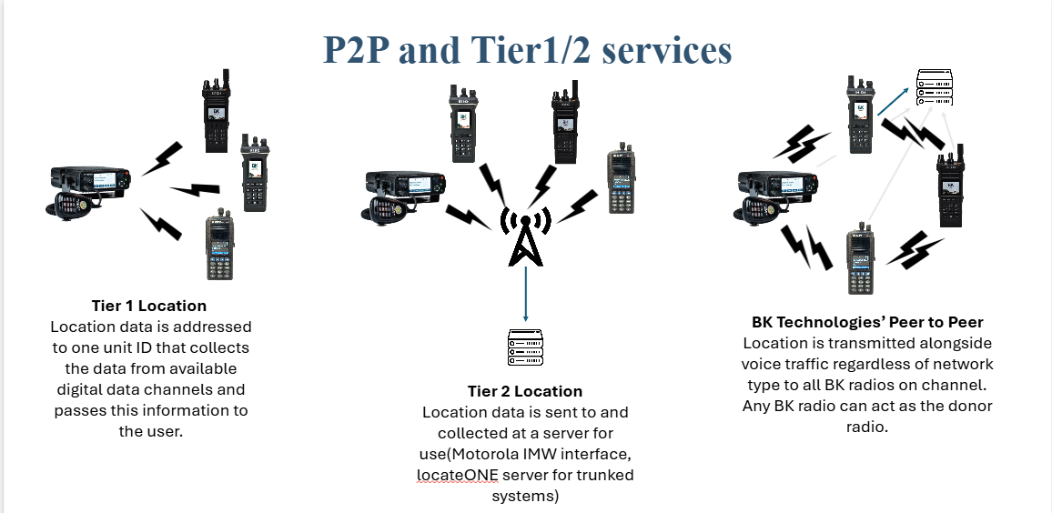
P25 Location Services Tier 1-
If the radio is on a P25 digital network, the radio can be configured to send its location data to a designated radio based on P25 Unit ID (UID). This radio can then be connected to compatible asset tracking software and ultimately display radio location data on screen, in a user friendly manner, most commonly as an overlay on a map. This data is sent over a digital P25 conventional channel to a designated station relay. The radio can be triggered to send its location based on various conditions, to include:
-PTT
-Periodic
-Emergency
-Power On/Off
The “All Call” Unit ID of 16777215 can be used to broadcast this tier 1 information to all P25 compliant radios regardless of UID.
P25 Location Services Teir 2-
If the radio is on a P25 Digital Trunked or conventional network, the radio can be configured to send Tier 2 compliant location to an IP based server. Once registered the radio will send its location data to the designated server for mapping. The radio can be triggered to send its location based on various conditions, to include:
-PTT
-Periodic
-Emergency
-Power On/Off
Peer to Peer location messaging –
The radio can be configured to transmit its location with every PTT to any radio that can receive the voice call. This Peer-to-Peer messaging is a one-to-many solution in contrast to the P25 solutions. It can work over analog using BK’s FAST data messaging, it can work over P25 digital conventional, and P25 FDMA (Phase 1) Trunking. The radio sends its location in every voice call as ANI data in analog or along the low-speed data channel for P25 conventional or trunked systems. There is no additional data loading on to the network.
Radios can be programmed to display the transmitting radio’s lat. and long. location or a cardinal direction and distance of the calling radio.
FAST Data Messaging
Utilizing a FAST data burst a the pre or post voice transmission the radio is capable of transmitting the radios MYID, hardware ID, and location.
MYID
Configurable from the radio’s keypad, MYID is a dynamic, 10-digit ID. This ID is separate from the radio’s assigned P25 IDs. For easy integration with BK ONE’s service such as interopONE, BK suggests utilizing a user’s 10 digit phone number, as this information is reasonably likely to be unique, and readily available.
BK Software Mapping Solutions
BK currently supports two mapping solutions, LocateONE and LocateONE Lite.
LocateONE
LocateONE allows for mapping of location data. A donor radio is connected to the location data engine and then map viewers access the location data. LocateONE can group radios users together, provide historical breadcrumbs, and provide current situational awareness. LocateONE supports both P25 standards and BK’s Peer to Peer allowing for interoperability flexibility with other Radio Manufactures. LocateONE also allows for integration with other GPS enabled equipment such as cellular modems, phones, and AVLs. As well as integration with popular software solutions such as CityWorks, and mapping solutions such as ESRI.
LocateONE Lite
Harnessing the power and capabilities of TAK, LocateONE Lite is an ATAK plug-in that connects an Android phone via Bluetooth to a BKR series radio. Once connected the radio will share all received location data with the ATAK software. This gives users flexibility to TAK and its various mapping capabilities alongside their BKR series radios. If there are multiple ATAK phones that can connect to an ATAK server, that data can be shared even further for more situational awareness in the most austere of environments.
What is TAK?
The Android Team Awareness Kit (ATAK), for civilian use, or Android Tactical Assault Kit (also ATAK) for military use - is a suite of software that provides geospatial information and allows user collaboration over geography.
ATAK was originally developed by the Air Force Research Laboratory (AFRL) and is now maintained by the TAK Product Center (TPC).(Source: https://www.civtak.org/atak-about/)